Post by August on Dec 25, 2013 5:28:01 GMT -5
Marin
Sausalito

"Sausalito is a San Francisco Bay Area city in Marin County, California, United States. Sausalito is 8 miles south-southeast of San Rafael, at an elevation of 13 feet. The population was 7,061 as of the 2010 census. The community is situated near the northern end of the Golden Gate Bridge, and prior to the building of that bridge served as a terminus for rail, car, and ferry traffic. Developed rapidly as a shipbuilding center in World War II, the city's industrial character gave way in postwar years to a reputation as a wealthy and artistic enclave, a picturesque residential community (incorporating large numbers of houseboats), and a tourist destination. It is adjacent to, and largely bounded by, the protected spaces of the Golden Gate National Recreation Area."
Tiburon Peninsula

"he Tiburon Peninsula is a landform of the San Francisco Bay Area's Marin County and incorporates the communities of Tiburon and Belvedere, California. Much of the land area of the Tiburon Peninsula was part of a Spanish land grant originally given to the early Californian John Reed. A prominent feature of the Tiburon Peninsula is Ring Mountain, Marin County, which forms the backbone of the peninsula and is the highest elevation of the peninsula. The Tiburon Peninsula is the locus of a number of rare and endangered flora species, and is also the site of ancient Native American rock carvings. The mineral lawsonite was first described from an occurrence on the Tiburon Peninsula."
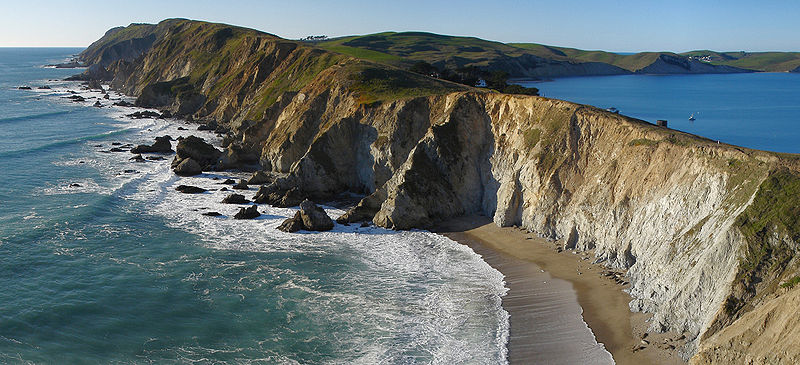
Point Reyes

"Point Reyes National Seashore is a 71,028-acre park preserve located on the Point Reyes Peninsula in Marin County, California, USA. As a national seashore, it is maintained by the US National Park Service as a nationally important nature preserve within which some existing agricultural uses are allowed to continue. Clem Miller, a US Congressman from Marin County wrote and introduced the bill for the establishment of Point Reyes National Seashore in 1962 to protect the peninsula from residential development which was proposed at the time for the slopes above Drake's Bay. The mix of commercial and recreational uses was the reason the area was designated a National Seashore rather than a National Park. All of the park's beaches were listed as the cleanest in the state in 2010."
Angel Island

"Angel Island is an island in San Francisco Bay that offers expansive views of the San Francisco skyline, the Marin County Headlands and Mount Tamalpais. The entire island is included within Angel Island State Park and is administered by California State Parks. The island, a California Historical Landmark, has been used for a variety of purposes, including military forts, a US Public Health Service Quarantine Station, and a US Bureau of Immigration inspection and detention facility. The Angel Island Immigration Station on the northeast corner of the island, where officials detained, inspected, and examined approximately one million immigrants, has been designated a National Historic Landmark."
Sausalito

"Sausalito is a San Francisco Bay Area city in Marin County, California, United States. Sausalito is 8 miles south-southeast of San Rafael, at an elevation of 13 feet. The population was 7,061 as of the 2010 census. The community is situated near the northern end of the Golden Gate Bridge, and prior to the building of that bridge served as a terminus for rail, car, and ferry traffic. Developed rapidly as a shipbuilding center in World War II, the city's industrial character gave way in postwar years to a reputation as a wealthy and artistic enclave, a picturesque residential community (incorporating large numbers of houseboats), and a tourist destination. It is adjacent to, and largely bounded by, the protected spaces of the Golden Gate National Recreation Area."
Tiburon Peninsula

"he Tiburon Peninsula is a landform of the San Francisco Bay Area's Marin County and incorporates the communities of Tiburon and Belvedere, California. Much of the land area of the Tiburon Peninsula was part of a Spanish land grant originally given to the early Californian John Reed. A prominent feature of the Tiburon Peninsula is Ring Mountain, Marin County, which forms the backbone of the peninsula and is the highest elevation of the peninsula. The Tiburon Peninsula is the locus of a number of rare and endangered flora species, and is also the site of ancient Native American rock carvings. The mineral lawsonite was first described from an occurrence on the Tiburon Peninsula."
Point Reyes

"Point Reyes National Seashore is a 71,028-acre park preserve located on the Point Reyes Peninsula in Marin County, California, USA. As a national seashore, it is maintained by the US National Park Service as a nationally important nature preserve within which some existing agricultural uses are allowed to continue. Clem Miller, a US Congressman from Marin County wrote and introduced the bill for the establishment of Point Reyes National Seashore in 1962 to protect the peninsula from residential development which was proposed at the time for the slopes above Drake's Bay. The mix of commercial and recreational uses was the reason the area was designated a National Seashore rather than a National Park. All of the park's beaches were listed as the cleanest in the state in 2010."
Angel Island

"Angel Island is an island in San Francisco Bay that offers expansive views of the San Francisco skyline, the Marin County Headlands and Mount Tamalpais. The entire island is included within Angel Island State Park and is administered by California State Parks. The island, a California Historical Landmark, has been used for a variety of purposes, including military forts, a US Public Health Service Quarantine Station, and a US Bureau of Immigration inspection and detention facility. The Angel Island Immigration Station on the northeast corner of the island, where officials detained, inspected, and examined approximately one million immigrants, has been designated a National Historic Landmark."
ALL INFORMATION AND PICTURES (C) TO WIKIPEDIA


